Leg 4: Tulsa OK to Adrian TX.
I picked up on Route 66 in Tulsa, where I ended in November 2015 when wintery weather set in. Adrian TX is the official halfway point of Route 66, though for me it will be more than halfway because I went out of the most direct route taking the KATY trail through Missouri.
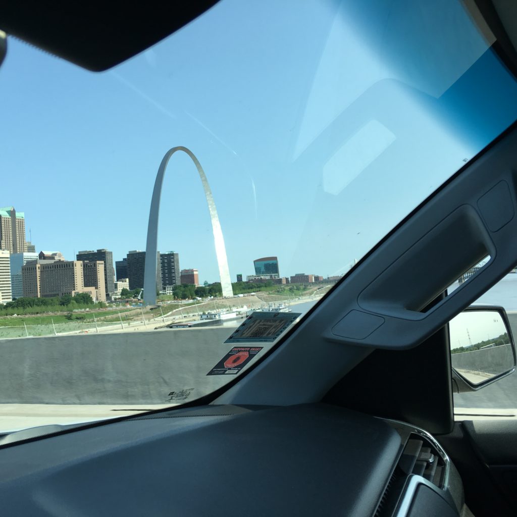
Corky, my friend of more than 50+ years from our start at Lane Tech HS through graduation and onto to U of Ill, rejoins me on the adventure. On his drive from Chicago to Tulsa he captures the iconic image of our Leg 1 termination point, the Arch at St Louis.
According to Google maps for a default bicycle route, adjusted so that it goes through Oklahoma City, as did old Route 66, it is a trip of 390 miles. As will be noted, it actually was a trip of 470 miles by the ACA Route 66 map including a few ‘extensions.’

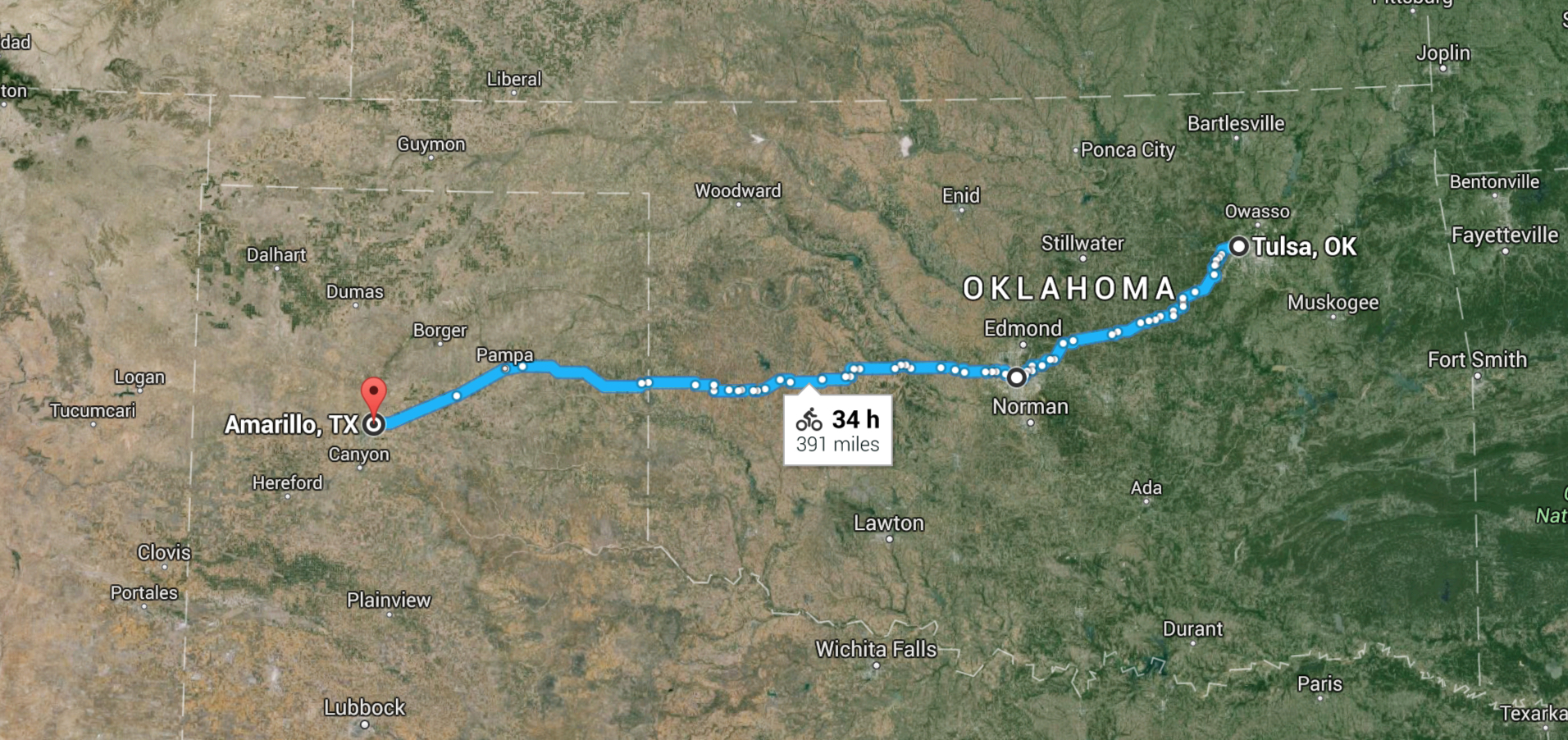
Google maps also shows the elevation change, both total ups and downs and the net (in this case) up. (What is a little confusing about the below representation is that Tulsa is at the left and Amarillo is at the right, which is a contra-indication to the direction of travel in the above maps which, in accordance with North being at the top, is East to West is Right to Left).
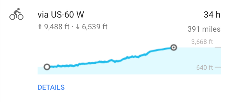
So although the net climb is pretty large, about 3,000 feet, the cumulative climb adding up all the intermediary hills is nearly 10,000 feet (!) or almost 2 miles up. Yes there is 6500 feet down, which can be fun and exciting but the fun is over pretty quickly at 20-30 mph, and one has to curtain some of that excitement by burning off by braking the potential energy converted into kinetic energy to keep the speed in a manageable range, and then the climbs at 2-5 mph take a while, actually a long while. But this is all part of the joy of the trip, especially as one heads West toward the Rockies and the Continental Divide.
These hills, and the incessant wind, and my general aged condition, has led me to add an “E-bike” enhancement to The Orange Flash (TOF) making it The Electric Orange Flash (TEOF). The addition is the Bionx e-bike motor and Li-Ion battery that works as a pedal assist. My plan is to use it only for the uphills to assist my pedaling so that I am going uphill at the rate of the upper half of single digits instead of the lower half of single digits. (As you will read, and as I discovered, this goal will not be fully achievable, but the Bionx was a huge help, and I am a big fan of the system). Details of the Bionx is given here.
The trip from Tulsa to Adrian took 8 days and covered 470 miles as detailed at the links below. However severe stormy weather caused us to rearrange the travel. Days 1, 2, and 3 were westward, as all the other days on all the other legs, getting us from Tulsa to El Reno OK, west of Oklahoma City. Then to avoid the weather streaming eastward from Adrian TX, we used our sag wagon to drive to Adrian TX, and began Day 4 in Adrain heading eastward, and so continuing on Days 5-8 ending back at El Reno OK. So we covered the entire ground by biking, but we did 3 days westward and 5 days eastward. The winds didn’t help or hurt the change as we had strong crosswinds the entire trip, going both directions.
Day 1: 5/16/16…Tulsa OK to Stroud OK (Westbound)
Day 2: 5/17…Stroud OK to Edmond OK (Westbound)
Day 3: 5/18…Edmond OK to El Reno OK (Westbound)
[drove from El Reno to Adrian TX, and biked on Day 4 starting at Adrian TX to Amarillo, to avoid waves in incoming storms, & begin biking Eastbound back to El Reno]
Day 4: 5/19…Adrian TX to Amarillo TX (Eastbound)
Day 5: 5/20…Amarillo TX to Groom TX(Eastbound)
Day 6: 5/21…Groom TX to Erick OK (Eastbound)
Day 7: 5/22…Erick OK to Clinton OK (Eastbound)
Day 8: 5/23…Clinton OK to El Reno OK (Eastbound)